Wednesday, November 23, 2011

Chapter 18:Hawaii

Key Points:

  1. Hawaii's geological origins are volcanic, and the islands remain volcanically active.
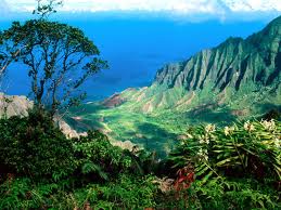
  2. The state's tropical location means warm climates, areas with high precipitation, and abundant plant and animal life.
  3. Hawaii's population is quite diverse and reflects a strong imprint of Polynesian, European, and Asian cultures.
  4. Although the islands' economies differ, tourism is important generally in Hawaii's economy more so than in most states.
  5. Nearly three-quarters of Hawaii's population lives in the Honolulu area.

Some background info on Hawaii:


Hawaii is the only state of the United States that is not geographically located in North America, grows coffee, is completely surrounded by water, is entirely an archipelago, has royal palaces, and does not have a straight line in its state boundary.Hawaii’s tallest mountain, Mauna Kea, stands at 13,796 ft (4,205 m) but is taller than Mount Everest if followed to the base of the mountain, which, lying at the floor of the Pacific Ocean, rises about 33,500 ft (10,200 m).

The eight main islands, Hawaiʻi, Maui, Oʻahu, Kahoʻolawe, Lanaʻi, Molokaʻi, Kauaʻi and Niʻihau are accompanied by many others. Kaʻala is a small island near Niʻihau that is often overlooked. 

All the Hawaiian islands were formed from volcanic activity initiated at an undersea magma source called a hotspot. As the tectonic plate beneath much of the Pacific Ocean moves to the northwest, the hot spot remains stationary, slowly creating new volcanoes. Due to the hotspot’s location, the only active volcanoes are located around the southern half of the Big Island. 

Hawaii’s climate is typical for the tropics, although temperatures and humidity tend to be a bit less extreme due to near-constant trade winds from the east. Summer highs are usually in the upper 80s °F, (around 31 °C) during the day and mid 70s, (around 24 °C) at night. Winter day temperatures are usually in the low to mid 80s, (around 28 °C) and (at low elevation) seldom dipping below the mid 60s (18 °C) at night.

According to the 2010 U.S. Census, Hawaii had a population of 1,360,301. In terms of race and ethnicity, the state was 24.7% White (22.7% Non-Hispanic White Alone), 1.6% Black or African American, 0.3% American Indian and Alaska Native, 38.6% Asian, 10.0% Native Hawaiian and Other Pacific Islander, 1.2% from Some Other race, and 23.6% from Two or More Races. Hispanics and Latinos of any race made up 8.9% of the population.

Although Hawaii has a warm climate it still differs tremendously from San Fran. There similarities are that they both attract tourists and that they are surrounded by water. 


Chapter 16:The North Pacific

Key Points:

  1. The physical geography of the North Pacific Coast is defined by rugged terrain and a wet climate with moderate seasonal temperatures.
  2. Because of its remote location, the region was explored and settled by Europeans and Americans later than other areas of North America.
  3. Except for Vancouver, Seattle, and Portland, there are relatively few large metropolitan areas in the region.
  4. Agriculture and logging are important elements of the region's economy, but both sectors are faced with relatively long distances to other North American markets.
  5. Seattle's economy is dominated by healthcare and biotechnology sectors and by two commercial firms: Boeing and Microsoft.
The North Pacific has a lot of nice scenary and snow, it is dominated with mountains. Very different from S.F.

Chapter 15: California

Our state has a whole chapter to itself, and its because we have a lot to offer, but the key thing here is San Francisco is located in California.


Some key points:


  1. California's physical geography is dominated by north-south oriented mountains/valleys and a mediterranean climate.
  2. The state's location on the Ring of Fire makes it prone to devastating earthquakes.
  3. California's agricultural productivity, valued at over $30 billion annually, is greater than any state in the country.
  4. Water is a scarce resource in parts of California and the state has had to undertake large water projects to provide for its growing populations.
  5. California's urban megalopolis has been largely shaped by use of the automobile, but automobile-related congestion and pollution continue to be problems. 
The Earthquake Zones:
The most famous fault, the San Andreas, extends from the Gulf of California through the Imperial Valley to Point arena north of San Francisco, where it extends into the Pacific Ocean. Lateral earth movement was as much as 20 feet along the San Andreas when the devastating 1906 San Francisco earthquake struck. 

"At almost precisely 5:12 a.m., local time, a foreshock occurred with sufficient force to be felt widely throughout the San Francisco Bay area. The great earthquake broke loose some 20 to 25 seconds later, with an epicenter near San Francisco. Violent shocks punctuated the strong shaking which lasted some 45 to 60 seconds. The earthquake was felt from southern Oregon to south of Los Angeles and inland as far as central Nevada.".....
"The frequently quoted value of 700 deaths caused by the earthquake and fire is now believed to underestimate the total loss of life by a factor of 3 or 4. Most of the fatalities occurred in San Francisco, and 189 were reported elsewhere."
http://earthquake.usgs.gov/regional/nca/1906/18april/index.php


The Gold Rush:
San Francisco was the supply port for the gold rush. San Francisco grew from a small settlement of about 200 residents in 1846 to a boomtown of about 36,000 by 1852. Roads, churches, schools and other towns were built throughout California. In 1849 a state constitution was written, a governor and legislature chosen and California became a state in 1850 as part of the Compromise of 1850 which divided possible US territories into free and slave states. Samual Brannan sold them shovels, picks, pans, and other items from his stores, he would gross $150,000 a month.

Smog:
San Francisco's smog level is considered good, they have special programs to educate people and have a smog free environment.
Bay Area:
  • Has the BART system as transport.
  • Has houses tall and really close together
  • ethnic neighborhoods
  • major pacific port

Saturday, November 12, 2011

Chapter 14: The Southwest Border Area: Tricultural Development

Key Features:


  1. The Southwest is dominated by three coexisting cultures: Spanish American, American Indian, and European American.
  2. Native American populations in the region are large and diverse, but less integrated into the American melting pot than other ethnic groups.
  3.  The Hispanic presence in the region dates back over 400 years, but populations have increased dramatically in recent decades because of immigration and higher than average rates of natural increase.
  4. The economy of the region is highly integrated with the relatively poorer areas on the other side of the border with Mexico.
  5. Population in the Southwest Border Area has exploded in recent decades.
San Francisco does not fall into this area but they do have something in common, both have a very diverse cultural background and it is also seen in the food. 


Chapter 13: The Empty Interior

Some key points:

  1. The physical geography of the Empty Interior is dominated by arid plateaus and dramatic mountain ranges.
  2. The federal government is a major landholder in the region and conflicts often arise over use of public lands.
  3. The Empty Interior is the core area of the Mormon religion in the United States.
  4. Although agriculture is present in the religion, irrigation is often a necessity, causing struggles for use of limited water resources.
  5. Tourism, mining, ranching, and lumbering play an important role in the region's economy.

The Empty Interior is complete opposite of San Francisco. San Francisco is densely populated and has a much cooler and moister climate. Although San Francisco is close to the empty interior they are very different. San Francisco has a lot of major company headquarters in its area such as: google, yahoo, pixar, C & H sugar. There isn't much dry/arid land in San Francisco, it is also by the ocean so that would not be possible.


Wednesday, November 9, 2011

Chapter 12: The Great Plains and Prairies

Review of the Great Plains

  1. Over the past 450 years, views of the Great Plains have shifted between a dry wasteland to a land of rich agricultural opportunity.
  2. The region has some of the least variation in vegetation and topography of any region in North America.
  3. Severe weather, including tornadoes, thunderstorms, and hail, is widespread across the Great Plains.
  4. Agriculture dominates the Plains economy and is characterized by large-scale operations and a high reliance on heavy machinery.
  5. The control and management of water is the most important natural resource issue in the region. 
The Great Plains covers southern Texas up to the Canadian Border, includes Oklahoma, Kansas, Nebraska, both N. and S. Dakota, Wyoming, Montana, Alberta, Saskatchewan, Manitoba. The landscape is low, flat terrain like, but in San Francisco the landscape is mostly hilly, there are 50 hills within the city. Mount Davidson is the highest hill  at 925ft. 

The climate in San Francisco has little temperature change with a cool breeze coming from the ocean, it is nothing like the plains. 

San Franciscos water is monitored by the SFPUC, which is responsible for 63,000 acres of water shed land, serving 2.4 million people. 

Friday, October 21, 2011

Chapter 11: The Agricultural Core

San Francisco, Ca is considered to be part of the West Coast, because it is in the Western part of the United States.

The soil types as reported by USGS are:


Soil type AVs > 1500 m/secIncludes unweathered intrusive igneous rock. Occurs infrequently in the bay area. We consider it with type B (both A and B are represented by the color blue on the map). Soil types A and B do not contribute greatly to shaking amplification.
Soil type B1500 m/sec > Vs > 750 m/secIncludes volcanics, most Mesozoic bedrock, and some Franciscan bedrock. (Mesozoic rocks are between 245 and 64 million years old. The Franciscan Complex is a Mesozoic unit that is common in the Bay Area.)
Soil Type C750 m/sec > Vs > 350 m/secIncludes some Quaternary (less than 1.8 million years old) sands, sandstones and mudstones, some Upper Tertiary (1.8 to 24 million years old) sandstones, mudstones and limestone, some Lower Tertiary (24 to 64 million years old) mudstones and sandstones, and Franciscan melange and serpentinite.
Soil Type D350 m/sec > Vs > 200 m/secIncludes some Quaternary muds, sands, gravels, silts and mud. Significant amplification of shaking by these soils is generally expected.
Soil Type E200 m/sec > VsIncludes water-saturated mud and artificial fill. The strongest amplification of shaking due is expected for this soil type.


The soils of the Agricultural Core is mollisols and alfisols.  Mollisols form in semi-arid and semi-humid areas, typically under a grassland cover.  Alfisols, like mollisols, also form in semi-arid and semi-humid areas, but under a hardwood forest cover.  The soil type in the Bay Area does not include these two types of soil.  The climate does not accomodate to help form them. There aren't any farms in SF because it is a densely populated city along the bay.

Chapter 10: The Southern Coastlands: On the Subtropical Margin

San Francisco's climate is not considered to be subtropical, a lot of parts of southern California do have similar climates to the subtropical margin but that is not what this blog is about.

One item that California dominates is orange production. We make the most edible oranges, while Florida makes the most orange juice.


Sugarcane is another major production of Florida and Hawaii, but California has a part in it as well. The refinery at Crockett refines, packages, and markets all of the output from Hawaii's sugar factories.  The C&H stands for California and Hawaii.   


Florida has the most retired/elderly people living in its state. But California, specifically San Francisco will be seeing a rise as well.
As stated in California Department of Aging, The percentage increase of aged people in San Francisco will rise 50-149% from 1990-2020.


Monday, October 10, 2011

Chapter 9: The Changing South

San Francisco is very hard to compare to the changing south because they have a lot of differences, but they also do have some similarities.

San Francisco doesn't have any huge plantations but they surrounding areas are famous for some things, such as the  vineyards of Sonoma County, and the garlic of Gilroy, CA in Santa Clara County.  


In 1865 Amendment 13 was passed abolishing slavery, with that said Ca was not even a slavery state it was a free state.


The Great Migration was cause for black people to start migrating, it was estimated that 2 million blacks people migrated out of the south and into the west side of the US. Ca offered people a safe haven and assistance for people who needed it. What most likely attracted immigration to the bay are was that there were a lot of job opportunities, and the economy was diverse. 


Besides economic reasons, the bay area had very nice temperatures and was clean of dust bowls, the beach is a very tempting place to be close to.

Friday, September 30, 2011

Chapter 8: Appalachia and the Ozarks


San Francisco has nothing to compar to the Appalachia and the Ozarks. The only forestry near the bay area would be the 559 acre Muir Woods National Park. It is actually in Mill Valley, Ca, Muir Woods is open every day of the year, including all holidays. Park hours vary throughout the year, but the park is generally open 8:00 a.m. to sunset. You will see the tallest type of tree in the world, the Coast redwood, sequoia sempervirens, as well as the countless other plants and animals that are part of an old-growth redwood forest, including tanoak trees, ferns, redwood sorrel, stellar jays, black-tailed deer, and banana slugs, to name a few.


There is also the Calaveres Dam, located at the Alameda-Santa Clara County line.  The dam is a 230 foot high barrier which holds the largest drinking water reservoir in the 9 county region.  Since its location is on an active fault zone, dam regulators drained the reservoir to about a third of its capacity.  The Calaveras reservoir sits in the Alameda Creek watershed, which drains most of the southern sections of the East Bay, including the southern slopes of Mount Diablo


Chapter 7: The Bypassed East


San Francisco is pretty much cold most of the year and gets a lot of rain. What we read about in our book “Regional Landscapes of United States and Canada” is that the bypassed east is also cold, with lots of precipitation, and mountains. Mountains are the biggest difference between the bypassed east and San Francisco. San Francisco’s temperature averages at 57 degrees F annually, the annual average precipitation is 22.28 inches and the most rain comes in January.

Mount Tamalpais, just across the Golden Gate Bridge, has a peak 2,604 ft. high; at its base is the Muir Woods National Monument.  Mount Tamalpais is the product of The North American and Pacific Plates sliding against each other, and it is also by the San Andreas Fault.

There is almost zero agriculture in the Bay area, first of all its covered in buildings second due to high pollution the soil is not the best for crops. But in Solano County they grow beans, sunflower seed, wheat, corn, almonds, walnuts, grapes, and alfalfa.  In Sonoma county there’s crops such as apples, mushrooms, watercress, and chestnuts.  But wine grapes dominate most of the crops in Sonoma.  


Wednesday, September 21, 2011

Chapter 5: The North American Manufacturing Core

Manufacturing is an important economic activity in the United States. The evidence of this is everywhere--in articles of clothing, items of preserved food, residential structures, means of transport and communication, and many other things. In spite of the presence of items manufactured outside the country, domestic industry remains paramount, and it is rare for any medium-sized U.S. town to be without at least some local employment in manufacturing. San Francisco is not part of the North American Manufacturing Core, but has some similarities.


The location of San Francisco means that there should be an easily flow with the means of transportation and communication.  The railway system is the Bay Area Rapid Transit (BART) which helps people commute in and out of the City without having to sit in their cars during traffic.  The central part of BART is San Francisco of course because of all of the office space that dominate the financial districts.  BART also makes stops at the Oakland Coliseum, SF Downtown shopping areas, and AT&T Park.  Many people also use the ferry system to commute to and from the City.  People who live on the east and north side of the bay frequent this mode of transportation.


Other famous manufacturing include: Levi's Jeans, New United Motor Manufacturing, Inc. (NUMMI) was built by General Motors and used to manufacture cars such as the Chevy Nova, Geo Prism, and Toyota Corolla.  The plant operated from 1984 to 2010.  When the plant closed more than 4,700 employees were out of a job. Some famous foods are del monte, Ghirardelli, and Rice o Roni.

Chapter 4: Megalopolis

Megalopolis that stretches the California coast from San Diego to San Francisco is considered to be a western model of the original megalopolis on the east coast, which was termed the SanSan by French geographer Jean Gottman. The Oxford Dictionary of Geography defines the term as "any many-centered, multi-city, urban area of more than 10 million inhabitants, generally dominated by low-density settlement and complex networks of economic specialization."

There are a few reasons why San Francisco can be part of a megalopolis. Part of it because they have the San Francisco Bay which is easily navigate-able for ships, Port of San Francisco which has been considered a natural harbor, and the Bay is spanned by six bridges (Golden Gate, Bay Bridge, San Mateo Bridge, Dumbarton, Richmond-San Rafael Bridge, and the Carquinez). With the Pacific Ocean as a route to Asia, the Bay Area has been a stop for freight liners to drop off their cargo.  The area is also linked to several major freeways, such as Interstate 5, US Route 101, California Route 99, and Interstate 80. 
   
The Northern California megaregion is home to the Silicon Valley with major corporations such as Cisco SystemsApple Inc.OracleEBayYahoo!,FacebookYoutubeGoogle, and Hewlett Packard, the San Francisco Financial District (headquarters of various financial firms such as VISA,Wells Fargo, and Union Bank of California), Wine Country, and much of the Central Valley which is one of the world's most productive agricultural areas, producing 8% of the nation's total crops. The centers of major national government offices, such as the United States Court of Appeals for the Ninth Circuit, the Federal Reserve Bank of San Francisco, the U.S. Mint as well as the California State Capitol are all located within the region. The Bay Area also has the largest concentration of multi-millionaire households of any metropolitan area in the country and the largest concentration of Billionaires of any U.S. metropolitan area.
 (http://en.wikipedia.org/wiki/SanSan)


Saturday, September 10, 2011

Chapter3:Foundations of Human Activity

Expansion of the European settlement frontier in San Francisco: between 1810-1830 had a population density of 2 or more persons per square mile.

Population density as of today is 300.0 to 2,999.9 people per square mile by county.

San Francisco is one of the largest urban ares in the U.S as of 2000 Metropolitan population ranking, they are at rank number 5.

Eating Preferences based on % of eating establishments:

  • chicken: 2.9-6.5
  • seafood: 0.7-3.3
  • steak: 0.8-2.2
Predominant relegious affiliations
  • Relegious group- Catholic Church
  • Number of counties-1,259
Tribes that lived in San Francisco
  • The Ohlone people, also known as the Costanoan, are a Native American people.
Contemporary Ohlone Groups
  • Muwekma Ohlone Tribe, San Francisco Bay Area
  • With 397 enrolled members in 2000, the Muwekma Ohlone Tribe comprises "all of the known surviving Native American lineages aboriginal to the San Francisco Bay region who trace their ancestry through the Missions Dolores, Santa Clara and San Jose" and who descend from members of the historic Federally Recognized Verona Band of Alameda County. On 21 September 2006, they received a favorable opinion from the U.S. District in Washington D.C of their court case to expedite the reaffirmation of the tribe as a federally recognized tribe.
  • http://web.archive.org/web/20090509075105/http://www.muwekma.org/news/index.html
Total Population Percentage of race in CA in 2000
  1. American Indian and Alaska Native:0.9-4.9
  2. Black or African American:5.0-12.2
  3. Asian:3.6-12.4
  4. Hispanic or Latino Origin: 25-98.8
European Settlement expansion occured in 1750-1850

Megalopolitan growth is seen in San Francisco area
  • Between 1990-2000 there was a 12.6% growth of population in San francisco


Friday, September 2, 2011

Chapter 2: Geographic Patterns of the Physical Environment

Some Basic Facts:

  • Physiographic Region- Pacific Mountains and Valleys
  • Percipitation- 20.0-39.9 mean annual percipitation in inches.
  • Climate Regions- Humid Mesothermal(Csb) Mediterranean or dry summer subtropical. Warmest month mean under 71.6 degrees F, at least 4 months have means over 50 degrees F.
  • Vegetation Regions-Cold needleleaf foorest and coastal forest.
  • Soil types- Highlands and Xeralfs
  • Metallic minerals- nothing major just some types of sediments.

Wednesday, August 31, 2011

Chapter 1: Regions and Themes

San Francisco has a land area of about 46.9 square miles (121 km2) on the northern end of the San Francisco Peninsula giving it a density of about 17,179 people per square mile (6,632 people per km2). It is the most densely settled large city (population greater than 200,000) in the state of California and the 2nd most populated large city in the United States after New York City. The 2010 Census report, found that there are 805,235 people living here.